Virginia Roads
A collection of information and personal research
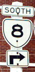
VA 8
Current Route
VA 8 starts at the North Carolina state line in Patrick County and runs north into Stuart, where it joins US 58. It crosses the Mayo River on the "T. J. George Memorial Bridge" (named by the State Highway Commission on January 1, 1957). The two roads run north together to Cruzes Store, where VA 8 continues northeast. At the junction with the western end of VA 57, VA 8 turns north and runs through Buffalo Ridge and continues through Woolwine. It exits to Floyd County at Tuggle Gap, running under the Blue Ridge Parkway.
It runs north to Floyd, where it crosses US 221. It continues north of Floyd, exiting to Montgomery County at Little River, crossing the Altizer Bridge (named by the State Highway Commission on September 5, 1957). Sections of the road between Floyd and the county line have been improved, with several sections of new location, leaving oxbows as Virginia secondary routes and a few places of abandoned roadway.
In Montgomery County, VA 8 runs north through Riner and enters Christiansburg on West Main Street, where it ends at US 11 at Radford Road. The continuation of VA 8 through Blacksburg and Giles County is now the route of US 460.
1933 Route
June 1, 1932 Revised July 1, 1933
Routes from county highway maps published by:
Virginia Department of Highways
Division of Surveys and Plans
Richmond, VA
Patrick County
Starts at North Carolina state line and runs north as a hard surface road into Stuart, where it joins US 58. The two roads run north together to Cruzes Store, where VA 8 continues northeast as an unimproved road. It runs through Buffalo Ridge, where it turns north, and continues through Woolwine, exiting to Floyd County at Tuggle Gap.
Floyd County
Enters from Patrick County at Tuggle Gap and runs north to Floyd as an unimproved road, where it crosses US 221. It continues north of Floyd, exiting to Montgomery County at Little River.
Montgomery County
Enters at Floyd County line, runs north through Riner to Christiansburg, entering on College Avenue. Runs through Christiansburg via Depot Street to Cambria. Jct. with VA 111, which runs to intersection with US 11 east of town. Continues up Cambria Street and north to Blacksburg. Enters Blacksburg via Ramble Road/Airport Road to Main Street. Runs with VA 114 from Roanoke Street to Prices Fork Road. Continues north out of Blacksburg, crosses Brush Mountain, and exits to Giles County on Sinking Creek Mountain.
Giles County
Starts at Montgomery County line and runs northwest to Newport, where it intersects VA 42 running east and Va. 605, Spruce Run Road, running west. It continues west, with an intersection with VA 112 to the north. At Maybrook, VA 42 runs west. VA 8 continues through Hoges's Store, Pembroke, crosses the New River and goes through Ripplemeade and on to Pearisburg, where there is a juntion with VA 100 south. It continues to Bluff City, then stays on the south side of the New River to Narrows. From Narrows, it crosses the New River, then continues on the north (east) side of the river to Rich Creek and a junction with VA 124. From Rich Creek, it runs north, then turns west, crossing the New River, going through Glen Lyn and exiting at the West Virginia state line.